
I’m going to start this post in two ways. First, the post that’s bubbling up inside me. The other way will be the more traditional type of account I’ve been posting.
Option 1:
TORNADO!!! TORNADO!!!!! OH GOD I SAW A TORNADO!!!! WE WERE THERE FOR EVERYTHING. IT WAS AMAZING AND I FINALLY DID SOMETHING I ALWAYS WANTED TO DO AND IT’S BEFORE I TURNED FORTY HOLY SHI-
**head explodes**
Option 2:
Do I even need to mention how long this post will be?
I’m pretty proud of myself for this chase. It was my first attempt to do things the right way, and man did it pay out.
Let’s talk weather.
I knew about four days out that today would be a chase day. It had everything I wanted before I knew anything weather related about it. It fell on a weekend, so I could take Heather with me. It was centered in northeast Colorado, so it’s easily in range for a day chase. What more could I ask for? This setup is the reason I moved here, and I don’t know anything else about it yet!
As the day approached I hit the books, so to speak. I spent a couple of days trying to learn to interpret model data and read Skew-t’s, while watching the event thread on Stormtrack. Conversation there about the day’s potential started to sound pretty skeptical, mostly due to low moisture.
Why is that important?
(Any storm chasers reading this may opt to tune out briefly, or audit what I say and tsk at my poor understanding of basic meteorology).
To get a storm, more to the point to get the BIG storms (tornado producing supercells), you need a mix of the following:
- Moisture
- Lift
- Instability
- Sheer
I’m not going to go into “how much is enough?” or the dynamics that come into play here because this is a chase log, and because any attempt at me explaining it will probably annoy, insult, and/or enrage people who have actually gone to school for this. Suffice it to say that if you are missing any of these four things in significant amounts, you will probably not get what you’re after.
There’s a huge caveat to this. Things can change on the day of, or storms can surprise you. There have been major tornadoes that occur on what appeared to be “off” days.
This ends my sad attempt to explain why today may not have gone so well.
What they were saying concerned me some, but not a lot. Colorado is a dry state, in many ways dryer than my home state of Arizona. Don’t believe me? Ask our cats, who are slowly being electrocuted by the amazing amounts of static electricity we deliver to their heads. We have to run humidifiers in our apartment.
Weld County, where Greeley is, has one of the highest number of tornadoes per year in the US. Not Kansas or Oklahoma. Colorado.
Saturday. Chase day. A couple of hour drive to possibly see a tornado. We. Are. Going.
But where to go?
On Friday, I forced myself to start REALLY digging into two forecast models, the GFS and NAM. Long story short, I still don’t know enough to completely understand the data. So I tried to check each of the (many) potential factors involved to see what area(s) would have the best concentrations of them based on a given time. Failing to see perfect correlations, I went ahead and aimed for a general region with the elements appearing to overlap or at least be next to each other.
In short, I still guessed…but I made a more educated guess. Akron, Colorado was our target.
We got up at 6:45AM and were out of the house just after 8AM. Someone’s dog jumped in Heather’s SUV while we were loading up, so we almost brought a dog with us. Man, if he knew what he signed up for…
After extracting the dog with the owners help, we headed out to gas up and buy ice for our ice chest. We packed light on the snacks and brought sandwiches (I can be taught!). I bought some cheese popcorn because that stuff is like crack to me. Just in time, I remembered to start the GPS tracker to log our trip.
We reached Akron at about 11AM, refueled, then headed south just out of town and proceeded to kill time on a country road. Heather shot time-lapse photos of the rapidly moving clouds. I finally changed out the rear windshield wiper on Heather’s SUV that we bought back in November. Heather tweaked her camera settings. I realized I left my tripod head mount at home and spent 10 minutes searching for it and cursing. Luckily, Heather had an extra cheapy tripod in her car. Crisis averted.
More time passed. I checked the radar occasionally, but nothing was happening in our neck of the woods. The Denver area though started to look pretty exciting. Then around 12:30PM, this happened.
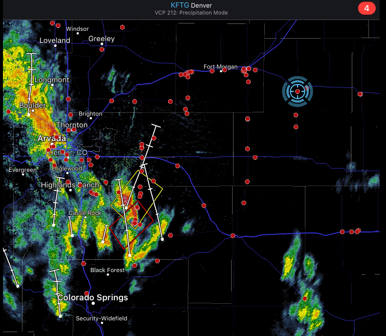
Well, crap. There’s a tornado warned storm just east of Castle Rock, at Kiowa.
I live 30 minutes from Castle Rock, and maybe another 25-30 minutes after that to Kiowa. It’s practically in our back yard. We’re 100 miles away now and the sky here is blue, with happy little white clouds.
So I missed a tornado. The day is young.
Checking the radar again, I see there’s some storms building to the south. Might be worth a look. I’m torn (ha! tornado pun) though. I’m seeing signs that Fort Morgan might be the place to go. Storms are really blowing up over there and there’s an awful lot of little red dots (chasers on Radarscope) heading that way. It’s easily within range. I resolved earlier not to chase storm chasers so we went south, to a little town named Anton to meet the storms heading north.
In retrospect, I might have gotten both targets. Fort Morgan had like 3-4 tornado warnings pop up as we headed to Anton.
We got to Anton just before 2PM and then headed east on route 36, stopping occasionally to take photos and video of the oncoming storms. Features were hard to make out at first, but we quickly started to see cloud bases, rain and hail shafts, and lots of SLCs. 1
During one of our stops, we saw a caravan of white vans drive by. A tour group. I couldn’t tell which one.
We continued east, a little faster now because the leading cell was almost to us and the radar indicated heavy hail in the core. We ended up behind the same group of white vans and we apparently all decided to stop at the same time, about 5 miles outside of Cope, Colorado. Another chaser pulled up a minute later. His name was Greg (I’m sorry I didn’t get your last name!) and he was a nice guy. Heather and I watched the storms with Greg for a minute and chitchatted. He thought the cells were merging (I had not noticed that), and said he was headed north to let the storms strengthen (which I had already decided to do before talking to him). Heather and I watched the tour group mill around for a minute. I thought I knew who it might be and got curious, so we went to go talk to them.
I was right! It was Silver Lining Tours, Roger and Caryn Hill’s company. I saw Roger, but we had a lot of people talking to him and I didn’t want to interrupt. Besides, those guys paid money to tour with Roger and his team and I didn’t want to interfere with that. I did meet Caryn Hill and she was very nice, but we (and by we I mean mostly me) were all talking somewhat distractedly, trying keeping an eye on the approaching storms, take occasional pictures, and carry on a conversation. Someone saw a funnel cloud and shouted out. It descended a little way, paused, and was gone in seconds.
Big drops of rain started to fall on us. By unspoken agreement, we all ran to our cars. Greg got away first. Heather and I followed and shot east to Cope, then north on Colorado Road 59. The tour company followed. 2
We played leapfrog with the tour for about the next thirty minutes. We’d stop, they would drive by. We’d take pictures until the rain started, then bail north again. We’d see a tour van pulled over and pass them. Sometimes we’d see Greg stopped. We continue on, then stop again. Repeat. It was kind of fun.
The storm looked to me at first like it was deteriorating on radar. At first I thought it might be dying, but there was still as LOT of inflow winds feeding into the storm. The radar updated again and this time the velocities showed clear, strong rotation. It’s definitely a supercell, and it was gaining strength. It was also gaining forward speed. Radar reflectivity was also showing a REALLY big hail core headed right for us. The NWS severe thunderstorm advisory said it might be producing tennis ball sized hail, which was a good incentive to run.
We hit Yuma, and had a short intense conversation on whether or not we had time for a bathroom break. We decided on yes, shamelessly used a Dairy Queen only for their restroom facilities (we later returned and got ice cream so reparations have been made), and headed east. We traveled a few miles east until we hit Eckley. I was more comfortable now that we’d miss the hail core. We stopped on the road to a landfill, then moved east a little further and took some lovely video and photos…in a graveyard.
We were very respectful, thank you. We stayed right by the car on the road.
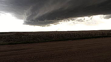
About five minutes later, the tornado sirens went off in Eckley, just to our north. I had never actually been in a town when that happened. My radar updated about thirty seconds later showing a tornado warning. According to that NWS bulletin, a spotter had seen a tornado.

We never saw one. We stayed for about 5 more minutes, scanning the skies and hoping to see anything resembling a funnel. Here’s what we saw looking to the north:
- To the right, looking west – a dark mess of rain and hail.
- To the left, looking east – a slowly approach mass of white. Almost definitely hail
- Directly in front of us – well…this! (Click image for full size)

We were now directly in the path. Of….something?
Being IN the tornado box was a new thing for me. It was something I knew would happen eventually, but I’d always planned on being on the back end of said storm, looking down the same direction the storm would be moving. Being in front of the barrel, so to speak, wasn’t something I’d really thought about. Especially if you consider how I chased on 4/26….way, way away from everything. I think I’ve overcompensated.
I knew we needed to get further east to get past the hail, so I told Heather we needed to leave in two minutes. Five minutes later, we packed up and left.
Too late.
We went straight into the core, luckily missing the worst of it. The hail was small enough (or soft enough) to not cause any noticeable damage to her car. I apologized to Heather multiple times. The hail stopped briefly, then came blasting right back a second later.
We cleared the hail core and headed into Wray around 4:40PM. We got to Interstate 345 and had a big choice to make:
- Go north and stick with the current storm. It’s got a possible history of tornadoes and it’s pretty strong.
- Head south and head for “Tail End Charlie”, the last storm in the line of supercells we’d been playing tag with all afternoon. It looked like it was organizing pretty well and we could just get south of the precipitation and sit right in the sweet spot if we hurried.
Just as we approached the turnoff, I saw the Dominator 3, Reed Timmer’s armored land monster. Holy crap..everyone is here!
Reed sees a LOT of tornadoes. It was really tempting to me to follow him for awhile. He certainly must know more about what’s going on in the sky than I do. I agonized. A lot.
The Dominator turned north. We went south.
About 15 minutes later the north storm became tornado warned. See? Reed knows more than I do.
We headed south and stopped on County Road 29. It was now 5PM and we realized that we’d never eaten lunch. We busted out the sandwiches, set up our cameras, and decided to film the storm base fast approaching us.
It came closer and closer. The mesocyclone signature kept tightening up on radar. The clouds were really racing and I started to see strong rotation. Little spin-ups were beginning to happen, completely invisible to us except for the dust swirls they stirred up.
It was headed for us. Oh. Shit.
I told Heather to pack up and we ran for the car. We jumped in the car and ran north for about a half mile. Heather jumped out and started taking pictures. I just started looking around. We seemed to be OK, I tho-
I looked up. They sky was rotating almost directly above us.
I told Heather we needed to move again, then I repeated it louder. She got in the car and started north again. “Did you see something?” she asked.
We went half a mile further north and got out. There was another SUV near us, with two chasers inside. Our windows were down. Their windows were down. I said something to the effect of:
“Get out and look straight up. Then we need to go north. Fast.”
I didn’t realize I was talking so loudly. The driver of the other SUV looked at me, looked up through his windshield, and started what looked to be a fairly animated discussion with his partner. We left. No idea on what those guys did.
I decided that we needed to move east, or we would get to be the chased. We were right next to County Road 31. We left the asphalt and went about a quarter mile down the dirt road, then stopped…
…and watched my first tornado touch down. It was amazing. Super photogenic! No rain, hail, flying debris. It was about half a mile away before it fully condensed (it was kicking up a big dust swirl well before that) and we saw the whole thing.

Filmed most of it too.
I was still a bit rattled by how close we’d been to violent cloud rotation, and a little stunned by the tornado itself before Heather said “Should we follow it?”
Oh! Yeah. We’re chasers. Right!
We took the first left and paralleled the tornado to the southwest, up country road “JJ”. Stopping to take pictures and video.

We saw it enter Wray, but because of the hill in our way we couldn’t see any damage it might have done. It looked like a direct hit though so we were worried. As we came down the hill, we saw a ton of emergency personnel all around an area. We opted to avoid that area instead of going and gawking at the damage (and maybe getting in the way).

Once into Wray, we navigated as quickly as possible to 3rd and Main St. Just as we turned right onto Main and started our northern pursuit, we got pulled over by a cop. We told him that we were aware of the tornado, and he asked if we would stay in town. He said that they were going to be closing Highway 385 to prevent people from leaving town and being injured.
I had mixed feelings on this. On one hand, I can appreciate his desire to protect people who might be travelling north who were not storm chasers. On the other hand, we have chosen to accept our own personal responsibility, and if we were not actually interfering with any emergency work (ambulances, search and rescue, etc.) why couldn’t we go north?
Apparently some chasers ahead of us managed to get north before the road closed, but this is pretty much where my log ends. I’d guess this is where the Dominator’s day ended too. We saw them get turned around by the roadblock and drive back past us. The last time we saw them they were driving around a motel parking lot.
I came up with a tentative plan to head west and navigate down the country roads north and west of town, then cut east to get past the roadblock. We started down, but after looking at the map and judging distances more closely, I decided that we would be left in the dust by the tornado.
We headed for Yuma, and my new favorite Dairy Queen 3, then southwest back home.
Lessons Learned:
- Here’s something you don’t want to see happen. More on that in a sec.
- I didn’t need to learn this next lesson, but Heather learned it quickly. Watch the ground as well as the sky! The 5 minute precursor to the Wray tornado had probably 5-10 ground swirls beneath and around the parent circulation. Any one of these most likely contained tornado level winds.
- Check your camera’s date and time before starting. Heather’s photo timestamps are about an hour off, making it annoying to correlate when things happened.
- Either buy a cheaper car, attach hail guards, or get better at moving BEFORE the hail gets to you.
- Once you set up your tripod, LEAVE IT SET UP FOR THAT CAMERA. Four things happened right before tornado time that really affected my video quality:
- On this chase, I decided to test an older Canon point-and-shoot camera that Heather used to use before she put on her big girl pants and bought a DSLR camera. She had a lot of batteries for it and we both had a lot of memory cards for it, so if it worked it might be a great addition to my gear! I wanted to try to manually adjust my aperture, focus, and ISO settings and see if I could get good video and pictures of the day. Good news, it was pretty successful! Almost.
- This meant, I removed my iPhone mount from my main tripod and attached the Canon camera on it. Then I was running back and forth from the car (to check radar) and back to my camera/tripod. A strong gust sent the camera straight into the ground.
- Right around this time, I realized just how close things had gotten and I knew we needed to move. I put the tripod with the camera still attached into the car and we left.
- Once we finally re-positioned the tornado was already touching down, and the last thing I wanted to do was move or troubleshoot a broken camera. I managed to get my little tripod attached to my iPhone, but the head is pretty flimsy because it’s cheap (and, to be fair, not meant for 40MPH+ inflow winds). I spent so much time holding the phone and tripod steady that I didn’t notice that my video was occasionally trying to autofocus. Sky photography has some quirks, but a very basic lesson on filming is “Set your focus manually to infinity and leave it, or you’ll regret it”. I didn’t lock my focus, so I’ve had to edit a lot of the iPhone’s sad attempts to focus out of my clip. Rookie move!
In short, I screwed with my gear setup and it wasn’t ready when I needed it. Maybe I should have just said that?
Finally, here’s a map of our chase.
